News
Use of drones in agriculture: a flight towards the future
News _ 30 NOVEMBER _2018
More and more frequently, we hear news about the utilization of drones in agriculture. Will be these innovative instruments the answer to new farms’ needs? Jump towards the future together with us and discover when this instrument could be useful.
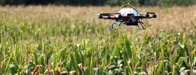
It’s a fresh morning in the American corn belt when John, drinking a cup of coffee, looks outside his house’s window to look at the sky. After some minutes he sees Thoroughbred, the little aircraft which, flying very low, is scouting the crops: an expanse of corn and soy, nearly interrupted for kilometers.
The little aircraft is an autonomous driving wing drone, equipped with hyperspectral cameras, NDVI and some experimental sensors, amongst which some miniaturized scanning lasers.
Thoroughbred flies once a week above the Consortium’s fields, established in 2022, which incorporates also John’s farm: 25 thousand hectares to scout in order to detect nests of Diabrotica barberi on corn, the presence of Halyomorpha halys (the harmful Asian bug) on soy. Above this, the drone controls also the water needs of the crops, to verify the proper arrangement of water saving activities.
The Data Center reaches a diabrotica alarm: the drone, which firstly makes a primary analysis of the data, finds the problem and, thanks to a specific software, communicates through the radio the location and the information. Automatically, the data are transferred to the farm controlling that field, at the same time the consortium operator examines them.
John receives the message, meanwhile the app on his smartphone/tablet instantly geolocates the position of the infected plant. For John this alarm is not a surprise: in fact he didn’t inform the consortium about the positioning of a new pump for irrigation, done the previous day, for which took out some sqms of corn.
John, pleased, takes a look to the app, thinking to the incredible precision of Thoroughbred and its components and how they responded to such a small anomaly. The choice to join the consortium was turning out to be a winning choice: the cost was been overtaken by the saving obtained from the utilization of pesticides.
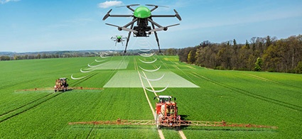
Now then, John should have informed the Data Center before the technicians sent out the Mule, as they call the hexacopter drone for precise treatments on crops. Corn plants laying down in a precise area would have been in any case, excepting this, a clear sign of maggots’ voraciousness.
After a two hours flight, Thoroughbred lands on a special airstrip at nearly 3 kms from John’s farm; there the technicians proceed with the installation of fresh batteries and the collection of data memorized during the flight to elaborate them definitively. After 30 minutes the Drone takes off again.
We will see a scenario like this, or at least, would be nice to see that happen. Anyway, before reaching this reality, where precision agriculture is based on drones, some conditions are necessary. First of all, we must think about their utility.
Drones in agriculture: usefulness
If drones, in some particular measure, will be able to supply a useful service, there will be an evolution on their utilize in agriculture. In order to grant a significative important information, it’s necessary that this information hadn’t been possible to gather before (without drone) or through high costs. The drone though, being just a displacement tool, like for instance an ATV Quad (often used in precision agriculture for making accurate measurements) or a tractor, the real innovation would regard the sensors (drone’s eyes) for long distance measurement/scanning. The sensors which work by contact or at very close distance are not obviously applicable on aircrafts, but they can be used for instance on combine harvesters, and other harvesting machines, specific implements and horticultural machines.
This reduces dramatically the advantages that can be obtained by an economy of scale, but it doesn’t eliminate them completely. The biggest problem though is represented by the autonomy of the drones, which is limited to just 10 minutes of flight approximatively; by the way, some companies are implementing drones for agriculture with the autonomy of nearly an hour, still containing the purchasing costs.
Talking about the value of the information, it can be sufficient to justify the use of the drone in case of alien parasites, like for instance the Diabrotica, which is cause of various concerns in Europe (Diabrotica virgifera), like it’s cousin in the USA.
Drones in agriculture though, may become more efficient and less expensive in the future, becoming also competitive with terrestrial vehicles. Nowadays, the cost of an information gathered by the drone is from 2 to 6 times more expensive than the information gathered in a “traditional way”. In a certain way, the tractor, in order to permit all the various operation, it has to transit through all the surface, that means the “transport cost” of the sensors is already absorbed by the operation. The gathering of the information may happen at the same time of a certain operation (for example weeding or treatment) and it can be less accurate, with consequence, a less accurate processing of the information. This is the very case of the sensors making all the checks on a particular phenomenon (presence of weeds even after weeding operation or, strength of the crop due to fertilizing operations) and the tool has to apply with a variable ratio, the substance in accordance to the previously gathered information. Being able to execute these operations, following a prescription map which has been formed on the basis of previous checking on the field, may result extremely useful. It will be a matter of verification if the monetary advantage brought by this method would be major than its costs. That’s the question: is it more convenient a flying vehicle than a terrestrial one?
In fact, even today we can have a clear view of the strength of the crops thanks to the information gathered by the satellite (for example Sentinel-2; Worldiew-2; Rapideye) which are in low definition but at least they are free or cost just some penny per hectar.
Drones in agriculture: sensors
Nowadays the sensors in agriculture capable of operate from few meters to thousands from the subject in analysis, are not in a large number, and all of them operate through the lecture of the solar radiation. Some sensors measure the wavelength of the evident, in other cases they operate outside the visible sphere, like for instance the multispectral sensors. The tale at the beginning of the article, in the end talks about the NDVI sensor: the only one which can be used today in agriculture (and with great success). This sensor can tell us the level of “strength of a crop”, analyzing the ratio between the reflectance, that means electromagnetic waves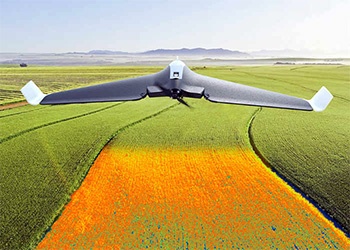
The sensor then is collaborating with an algorithm which translates the physical information (that means the ratio between the intensity of the reflected solar radiation and the one incident) into an agronomical informative unity (so an index that can express the difference during the living capacity of the plant, that mans NDVI).
A further step of processing of these information is characterized by the ability (or to help the farmer to do so) to identify the possible causes of these different values. For some crops for example, having at disposal the information regarding the seasons’ tendency, the adopted techniques and the soil profile, it is possible to understand clearly the cause of the problem. In citrus groves, the drone is used to to identify the plants which may be attacked by the Tristezza Virus (Citrus Tristezza Virus or CTV).
The drones may be also equipped with sensors able to detect the presence of gas, particles and atmospheric aerosols; till now though they didn’t find their place in agriculture.
Drones in agriculture: the Mule
We give this name, in memory of Asimov, to those multirotor drones which can be utilized for particular agricultural operations, till now involving just the distribution of pesticides. Furthermore, in sustainable agriculture scenario, the major part of their applications are related to the distribution of biological products or to 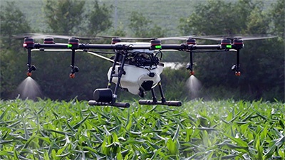
Also, the distribution of chemicals can bring advantages, thanks to the possibility to operate only where necessary (for example a small part of the field) also in presence of developed crop. Above this, the drones in agriculture can perform the treatment on all the surface, even when rainfalls or other meteorological events obstacle the use of the tractor in the field and in presence of deep slopes (like heroic viticulture).
The carrying capacity and the autonomy are still low, but they already allow with special vehicles with programmed flights and tank capacity of 2-3 lts, to perform the treatment on 4-5 hectares of vineyard in a full working day.
We have to precise though that the use of the drones for the distribution of pesticides is nowadays forbidden by the law. In fact, drones are treated as equivalent of normal flying vehicles (helicopter or airplane), so, as per art. 13 of D.Lgs. 14.08.2012, n. 150 and to art. 9 of Directive 2009/128/CE, they cannot be used for the distribution of pesticides in Italy and in the other Countries of the European Community. Only a few special cases are authorized by the Region.
Drones though, can distribute products not considered as pesticides, like for instance the Trichogramma in capsules, useful insects deployment, and other products allowed to be distributed by a flying vehicle.
Conclusions
The future of agriculture will be 100% sure about precision agriculture, but is not predicted that this will be based on the utilization of the drones. By the way, this won’t happen till we’ll use the four/six-rotors drones, with low flight autonomy, low loading capacity, which operate only if driven by an user on the ground and expensive.
To permit a useful/important role to the drones in agriculture, the following points have to happen:
- Reduction of the management costs of the drone, compared to terrestrial vehicles (that means improving autonomy, preferring winged drones, having the possibility of autonomous flight, developing farmers consortiums);
- A development of operative drones, the ones which have an active role. This means a major loading capacity, with better distribution systems (lighter and with more efficacy) and a full agronomic support;
- A wider range of information that can be gathered through long distance (from the sky as well);
- A development of the ability to examine and understand the gathered information (correlation between physical information and agronomic issue).
We hope this article has been useful to give you a clearer view of the way the drones can be used in agriculture and the benefits they can bring. If you have any doubt or question do not hesitate to contact us! One of our Forigo experts will be glad to supply to you all the information you need.

Research and Development Division of Forigo Roteritalia. Team of experts engaged in the study and analysis of the main agricultural and horticultural techniques used today. Knowledge combined with competence are the starting point for continuous improvement in a scenario of innovation and technological development.

